Westmount was Halifax’s first postwar subdivision, and is located on the site of the Original Halifax Municipal airport.
Opened in 1931, The Halifax Municipal Airport was owned by the city but was leased to the Halifax Aero Club until March 1932. Improvements were made and Pan America showed interest in establishing daily flights.
The airport now consisted of two runways, a hanger, oil and storage shed and a terminal building for the office and waiting room. The terminal building was 18’x20′ with a 6′ veranda. It had a phone and electric power but the toilets were chemical as there was no running water
All the buildings were painted Pan Am colours. Pan Am started a daily service between Halifax and Boston (approximately 475 miles) at the end of July 1931 with stops in Bangor, Calais and St. John.
the airport was closed in 1941, and the land was used as an Army Depot. in 1946 the land was turned over to the city. Construction of Westmount began in March 1948, and the 305 houses are of 4 designs. the Community was designed by Dumaresque and is based on Radburn New Jersey.
Radburn was developed in 1929 based on Howard’s Garden city Principles. it was touted “a town for the motor age”. Radburn created the residential super block, and ensured pedestrians never had to cross a major road at grade.
In Westmount, The Fronts of houses all face pedestrian walking trails, the roads are located in the rear and are intended to be service
All of the streets in the Westmount subdivision are presently named after local airmen and soldiers who fought and lost their lives in the Second World War.
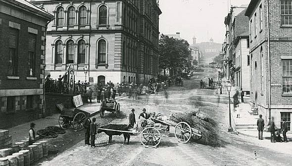
Steven Archibald recently posted Reckless Pedestrians where he looks at old photographs of Halifax, and compares how much more pedestrian-friendly they were in the days of the horse, before the car. This didn’t seem right to me, and caused me to go searching for urban transportation pre-automobile.
When you look at the photos, the people look posed. The streets are also relatively empty. It doesn’t feel like the hustle and bustle of a city. The reason for this lies in the technology used to take the images. Wet plate processes had existed since the 1850s but had 10 second exposure times. Dry plate processes in the 1870s improved exposure times greatly, but they still could be long enough that moving objects are not captured. The result of this, is that moving objects are not seen in the photos. People and wagons are posed. The blurs are moving people, who could not be exposed properly.
The horse itself was the cause for a great deal of muck on the streets. Each horse produced 15-30lbs of manure per day, and a quart of urine. Most of this would be deposited on the street. The horse-powered trams required 11 horses per day to run. The Sherbrooke, the Dartmouth ferry Team Boat, required 9 horses to power the vessel across the harbour, and the ferry company maintained multiple sets. Besides the muck itself, as it dried, it would form dust, and be swept into the air by the wind. The manure also attracted and became breeding grounds for common flies, which were discovered to carry numerous diseases, including typhoid. By the turn of the century, the motor car was seen as a savior from the muck, and a tool to improve the heath of cities.
On-street parking and horse drawn tram
Horse powered trams existed before the electric streetcar. The rails allowed for a smoother ride for passengers, and reduced resistance, which allowed the horse team to pull a larger load. The Halifax City Railroad was inaugurated in June 1866 , and ran from the foot of Inglis Street to Duffus Street in the north, terminating at the Nova Scotia Railway station in Richmond. Cars ran on the line every fifteen minutes from 6 a.m. to 10 p.m. until 1874, when frequency increased to every ten minutes between 10 a.m. and 8 p.m. The service was unprofitable, and the move of the train station to downtown (at the foot of North Street) caused the service to shutdown in 1876. The Halifax City Railroad stable and car barn was located at the corner of Hanover Street and Campbell Road. At the time of dissolution, they owned 50 horses, which were sold, along with the cars.
A Double Decker Horse Drawn Tram in the London Transport Museum
After 1876, Haligonians were forced to rely on Omnibuses. Omnibuses were a horse-powered wheeled bus. They were more expensive to use then the street railway, the ride was rougher, on account they were wheeled, and they had a lower capacity.
Example from London, London Transport Museum.
The Halifax Street Railway was formed in 1886. They purchased 15 new cars from the John Stevenson Company, as well as the stable and car barn used by the Halifax City Railway. They also purchased the omnibus service to eliminate competition. The Halifax Street Railway went bankrupt in 1889. it was purchased by the Nova Scotia Power Company, who intended to electrify the service. They too went bankrupt and and were purchased by the Halifax Electric Tramway Company in 1895. Electric trams started running in February 1896.
The other assertion is that the horse-powered vehicle is smaller then the modern car. However, this is not the case – the oxcarts in the photo of the market (2 above) appear to be 15-20′ in length, and the NSMMA has a Sloven on display, a type of typical Halifax freight wagon that by itself is 20′ long, not including the team. For comparison, my Nissan Rogue is 15′ long.
Cities included massive multi-level livery stables to accommodate the horses and carriages – analogous to our modern parking garages. Halifax had the Metropolitan Livery Stable on Hollis Street, across from the Halifax Hotel, Robinson’s Livery Stable on Doyle Street, and the Bengal Lancers Stable, which still exists as a stable, though in abbreviated form. Robinson’s Stable on Doyle still exists, though in much modified form. When the horse went out of common use after the First World War, the stable was converted to various other uses, including a car dealer, parking garage and most recently, office and retail space.
In NYC in 1900, 200 people were killed by horse and horse-drawn vehicles. There were 270 auto related deaths in 2012 (pedestrian and vehicle collisions). New York’s 2012 population was 8.3 million, it was 3.4 million in 1900. The roads in the time of the horse were much deadlier places to be. Chicago had similar stats. I was curious if I could find out what the stats for Halifax were, however I discovered that there were no death records kept in Nova Scotia between 1877 and 1908, though there is a ledger for Halifax.
William Phelps Eno was trained as an architect, however went on to become the Father of Traffic Control. In his books, he writes of the chaos he experienced in streets of New York, Paris and Italy, and how pedestrians had few safe places of refuge. As a boy, He rode velocipedes, early pedal-less bicycles in Paris. Though he died in 1945, he never possessed a driver license and was unable to drive himself.
Eno is credited with the creation of the first traffic code, which he did in 1903 for New York City. He is also credited with the invention of the crosswalk, stop sign, stop light, yield sign, the pedestrian island, the traffic circle and the one way street. Born in 1851, more then half his life was spent before the widespread adoption of the automobile. His primary goal in traffic control was to reduce the number of accidents caused by horse-drawn vehicles.
His code for New York explicitly gave right of way to road traffic.
Article IX. The Respective Rights and Duties at Drivers and Pedestrians. The roadbeds of highways and streets are primarily intended for vehicles, but pedestrians have the right to cross them in safety, and drivers of vehicles and street cars must exercise all possible care not to injure pedestrians. Pedestrians should, on their part, never step from the sidewalk to the roadbed without first looking to see what is approaching, and should not, needlessly, interfere with the passage of vehicles or street cars.
By crossing a street as nearly as possible at right angles, preferably at a regular crossing, and when a traffic policeman is stationed there, by waiting for his signal, pedestrians will greatly add to their own safety, facilitate the movement of traffic, and make it much less difficult for the horses, which often have to be reined in suddenly and painfully to avoid careless and unthinking pedestrians. Nothing in the foregoing should excuse drivers from constant vigilance to avoid injury to pedestrians under all conditions.
The Tramway Building was built in 1916, after a fire destroyed the previous building on the site. It is named Tramway, after its tenant, the Halifax Electric Tramway Company, Which operated Halifax’s streetcars until they were converted to trolly coaches in 1949. The 2 Storefronts are original to the building, Housing Tip Top tailors 1921-41 until they moved next door, and then Chas brown Furriers from 1942- 1983.
Designed by Andrew Cobb, in a Modern Neo-Gothic Style. It was one of the first all concrete buildings in Halifax (The first being the 1903 A.M. Bell Building on Granville St.) Cobb studied at Acadia , MIT and the Ecole des Beaux Arts, and Setup Shop in Halifax in 1909. He also worked as a partner with S.P Dumerasq. Cobb had his office in Tramway from 1938 until his death in 1943.
The building features a clear hierarchy of forms, separated by wide concrete banding, which separates the Retail street level from the second floor, and again form the second floor to the roof line. Octagonal turrets line the top of the building, though the Barrington street ones have been removed due to their poor condition. As of 2020 the building is undergoing a restoration which will restore it to its original appearance.
Located on Bedford Row at the corner of Prince Street, the No 4. Engine House was built to replace an older station also on Bedford Row, that in 1905 was declared unfit for men to live in by the Fire Chief. In May 1904, City Council: “Resolved, that the City Engineer be and is hereby instructed to draw and submit to this Council plans for the erection of an engine house on the property known as the Little Fuel Yard in this city.”
F.W.W. Doane, the city engineer, promptly advised council that his staff were too busy to prepare plans. Council then directed the city architects to submit plans, with acceptance of the plans determined on the merit (ie best plan wins). Council set the architects’ fee to 5% of construction cost for chosen plans, for plans and construction supervision. The budget was $10,000.
Sealed plans were received in November 1904, with coded submission forms. The plans from “Square and Compass” were chosen, and referred to Council for final approval. Plans were also received from Bluenose, Como, Salamanda, Cambria, Experience, and Citizen. The successful submission was that of R.A Johnson. Richard Arthur Johnson was a partner in the firm of Hopson Brothers, architects, and originally headed the Sydney NS office of the firm, but practiced in Halifax after that firm dissolved.
The building was influenced by the Chicago style of architecture with ornamentation, tall pilasters and wide Romanesque arches. The arches on the front Bedford Row elevation originally acted as the doors for fire apparatus.
By June 1905, plans were complete, and the project was put to tender. Five responses were received in July – two were non-compliant, and were rejected. Geo. B. Lowe was recommended with a cost of $16,535, and proposed to construct the station of concrete block. Council decided to send the tender back to the works committee, as the plans were to be for a $10,000 building and the lowest bid was $7000 more. Council also want to know if it was advisable to build with concrete block.
On August 15, the city works committee reported back to council. The architects who submitted plans all felt that $10,000 was too low a budget for a building; those who gave an estimate felt $14000 was the bare minimum price for the station. The proposed construction material – concrete block – was also addressed. It was initially thought that brick would be cheaper, and a petition against the use of concrete was received from the bricklayers’ union. Concrete block was a modern material and felt to be unproven, and was considered to be a cheaper material then stone (though concrete block was in wide use in cities west of Halifax). The blocks were proposed to be made by city labour, and laid by union masons.
In the end, Council accepted the tender of Edward Maxwell at a cost of $17,764 for a brick building with concrete trimmings. The building was complete by May 1906, and the final payment was released to the contractor.
After the station was completed, the architect made an unsuccessful attempt to collect a fee of 5% of the final construction cost of $17,764. The city ruled that the fee was to a maximum of $500, and this was clear when the design was awarded. R.A Johnston was paid $441.70 for his design and supervision services.
After opening, the roof leaked, and by February 1908 the contractor was unresponsive to requests from the city for warranty repair. The city solicitor was authorized to take action.
4 engine circa 1940.
Firefighters from this station would have responded to the fire that led to the Halifax Explosion. Ironically the re-construction of the devastated area would be done primarily with Hydrostone – a brand of concrete block manufactured in Eastern Passage, and 10 years prior considered too modern for the fire station.
Appearance in 1969 before closure. The arched doors were restored, and some brick uncovered after conversion.
The Station just after conversion.
The Bedford Row Fire Station served Halifax for over 50 years. In 1969, the Fire Station was closed, and converted to restaurant and office space and staff were moved to the new West St. Headquarters. The Current appearance is faithful to the original, though the rustication at the base has been lost, as has some of the detail of the brick work.
The Welsford-Parker Monument is a triumphal arch located in the Old Burying Ground. This is the second oldest war monument in Canada and the only monument to the Crimean War in North America.
The Monument was inaugurated in a ceremony on July 17th 1860, and the committee that erected it was composed of H. Pryor, A.M. Uniacke, W.J. Almon, J. Duffus, B. Binney, and J.C. Cogswell.
The Acadian Recorder for 21 July reported on the Inauguration:
The afternoon was clear, but uncomfortably warm. A little after 2 o’clock, the procession formed on the Grand Parade. It consisted of all the Halifax and Dartmouth Volunteer Companies, a large number of the Masonic body, and various public officials. These, paraded by bands of music, marched down Barrington Street to the old Cemetery, where detachments of the Regular troops of the garrison were already stationed. The military portion of the assemblage formed a hollow square around the Monument, within which ticket holders were admitted. A large assemblage, especially of the fair sex, were present to witness the proceedings; and the gloomy old graveyard for once presented a gay appearance. The ceremonies commenced with prayer by the Rev. John Scott. His Excellency the Lieutenant Governor, Lord Mulgrave then addressed the assemblage at some length and, in concluding, introduced the Rev. George Hill, the Orator of the day. Mr. Hill’s oration was an able and eloquent effort, and is, we understand, to be printed. Major General Charles Trollope also spoke in his usual popular and humorous style, and Rear Admiral Sir Alexander Milne made a few remarks. A great deal of cheering was done and the proceedings concluded by the Volunteer Artillery under the command of Captain Tremain, firing13 minute guns, and by the bands playing and the whole assemblage singing the National Anthem. We find that while the ceremonies were going on, Chase, the clever photographer succeeded in taking an excellent photographic view of the whole scene, a copy of which we have no doubt many people will hasten to secure, as a memento of the day and the event.
The arch and lion were constructed under the direction of George Lang to commemorate the British victory in the Crimean war and the Nova Scotians who had fought in the war. George Lang also was responsible for the Federal Building which is now part of the AGNS.
The memorial is named after two Haligonians, Major Augustus F. Welsford of the 97th Regiment and Captain William B.C.A. Parker of the 77 Regiment, who both died in the Battle of the Great Redan in 1855 during the Siege of Sevastopol.
The Gothic revival, began in Britain, and recalls the Gothic architecture of the 13th and 14th centuries in Europe. The neogothic movement was firmly rooted in the romanticism movement which placed and emphasis on emotion and individualism as well as glorification of all the past and nature, preferring the medieval rather than the classical. Canada experienced a huge interest in the Gothic revival, compared to other countries, causing the style to be in favor for over 100 years, gaining popularity in the 1820’s, and finally going out of style in the 1930’s.
St Marys basilica, is the seat of the Roman Catholic Bishop in Halifax. Located on the corner of Spring Garden road and Barrington street the initial construction of the church occurred between 1820-1830.
Catholics were not permitted to build a church in Halifax until 1783, presumably in an attempt preventing large numbers of predominately Catholic French from overrunning the city. The church of Saint Peter, a small wood frame building was constructed, and opened on July 19 1784. located roughly on the site of the current final 2 bays and apse, it faced Grafton street, and was in use until 1829.
The original facade is rather simple – three pointed arch doorways, with pointed arch windows above, with a projected central bay. The flat topped tower was terminated with a parapet and pinnacles on the 4 corners. though simple in form, the church slightly predates Montreal’s Notre Dame as first significant Gothic revival building in Canada.
The Gothic revival (or neo-gothic) style was based on romanticism, and renewed interest in the medieval period. The original Gothic period ran from the 12th to 16th century and was responsible for a number of very famous European churches. Neo-gothic details include Pointed arches, ribbed vaults and flying buttresses. The Gothic style was particularly suited to the Canadian climate, with steep roofs and thick walls. It also served to tie Canada back to its European roots.
J.S. Clow, 1840 watercolor of the original interior.
Though no notes or documentation of the original design survive, it is though that the interior is a gothic interpretation of Gibb’s St Martins in the Fields. Early Gothic revival buildings in Canada maintained a Georgian look to them – the form and proportions of the building were Georgian, but featured gothic detailing. The initial interior of St Mary’s, The Nave and isles are present, as the the vaults without ribs. The interior appears to be faced stone, but is most likely plaster imitation. The Church featured a Semi circular Apse, though it appears to be screened from the nave by a series of pointed arches. also notable are the galleries above the aisles.
An extensive renovation program begun in 1862 Saw the original church building expanded with the demolition of the original apse, construction of an additional 4 bays and a new 5 sided polygonal apse. The expansion was the work of designed by Irish born, Brooklyn based architect Patrick C. Keely. In his expansion, he chose to integrate and renovate the existing church. Among the changes, Keely installed larger windows, replacing what had formerly been 2 windows per bay with single larger lancet window.
The interior changes included a new Apse, and the removal of the side galleries, opening the aisles to the roof. the vaults were ribbed, and the style of the Columns was changed. St. Marys basilica as we know it today is best known for its granite Facade, which was erected later in the renovation program between 1868-1874. The remainder of the church is constructed of iron stone, and Gothic details are limited to Lancet windows.
1870, with new tower being installed. Note Glebe house same as in 1840 engraving
The St. Mary’s Glebe House on the Corner looks Georgian in form and proportion but if you look closely, you can see Gothic details over the windows, and the entry porch. this Glebe house was erected in 1802.
The Canadian Architect and Builder Featured a plate and wrote of the New Facade in 1893
“St Mary’s Cathedral is regarded as being the finest sacred building in Halifax. The architect was a Mr. McCarthy of New York. The entire front and spire is built of Dressed granite. The sides are not in keeping with the front of the structure, but are built of iron stone with free stone facings. it is a matter of regret that a structure upon which so much money has been spent should be finished in this manner. if the whole building had been completed in a style to correspond with the front, and erected in a square by itself instead of allowing other buildings to hide a part, it would have shown to much better advantage.”
heaping some criticism, obviously unaware of the buildings history, and Getting the name of the Architect wrong.
St Matthews United Church,located just around the corner from St. Marys on Barrington street, dates back to 1857, when the original 1754 building burned. Built at a new site, the church is located on the Barrington street side of Bishop Binneys lot.
the Church is built in a simpler Gothic style, and is less ornate then the final St Marys, but likely very similar in appearance to St Marys as she originally Existed prior to renovations. St. Matthews is in many ways a larger version of many of the gothic churches that exist in smaller communities around Scotia.
The current St Mary’s Glebe House was built in 1897, and also features Gothic detailing but is more eclectic in nature. Somewhat more understated are the ChurchField barracks. The ChurchField Barracks, (locally known as the 12 apostles) are a 12 unit townhouse on Brunswick street. The ChurchField Barracks originally served as married Officer living quarters, for officers stationed at Citadel hill. They were built in 1903 by the British Army.
The Churchfield name comes from the fact that they were built on the Garrison Chapel Grounds, the chapel itself located at the corner of Brunswick and Cogswell. Most of that context has since been replaced, largely due to suggestions that the land was prime area for expansion in the 1946 Master plan.
The Historic Places registry describes the Barracks “as a good example Gothic Revival style and is unique within Nova Scotia. The units feature steeply pitched gabled roofs with covered porch entrances that provide shelter and easy run off of rain and snow. Each unit features a gabled Gothic style dormer and an enclosed porch with a small window. As well each unit has a sentimental window on the first story with radiating voussoir and sandstone window sill. “
Floor Plan Courtesy of the Eleventh Apostle Blog – the blog of a full gut and renovation of the 11th unit. It includes Lots of pictures of what the insides look like.
Halifax was founded in 1749 as a result of Louisbourg being handed back to the french in 1748. The American Colonies, led by Governor William Shirley of Massachusetts wanted a buffer between them and the french, as did the Board of trade and Plantations, led by Lord Halifax, whose job it was to Advise the king on Colonial matters.
The town site was laid out by military engineer John Brewse,and Capt. Willliam Morris, from Boston, who would become the first surveyor general of Nova Scotia. Halifax was surveyed into 5 blocks in the North/South direction, and 7 blocks from the Harbour up citadel hill. these blocks were then subdivided into lots. The whole town was surrounded by a Palisade and several blockhouses for defense. The first Citadel was built at this time, atop citadel hill opening on Sept 11, 1749. Constructed of wood, this Fort would be replaced in 1761, having succumb to rot and deterioration due to weather.
Lots were assigned in August 1749, and Construction Began. Houses outside the Pallisade are thought to have been built from logs, though those within the town site were built of framed lumber. Military Barracks and officers quarters were delivered pre-cut and labeled from Boston. It’s believed many other buildings were constructed this way to ensure all the new inhabitants had shelter by winter.
The first views we have of Halifax are from drawings done by Richard Short, and latter engraved.the drawings depict the town as it was in 1759 shows a view of Halifax from the Corner of Hollis and George Streets. You can st St. Paul’s in the background, and the Governors mansion in the foreground. The Original governors mansion would become the site of Province House in 1809, and St Paul’s still stands as the last building in Halifax original to Cornwallis’ time in town.
Settlers from England and the American colonies were in short supply and there was a need to bolster the population of Halifax. Many of these settlers were German speaking Protestants, who built a community just north of the original town site, located where the little dutch church stands to this day. Built of logs, and covered in clapboards, it was constructed in 1756
the building that is now know as The Carleton began as Richard Bulkeleys mansion, built in 1760, it has been suggested that the stone used was salvaged from the Second Fall of Louisbourg in 1758. One of the Fireplace mantels was originally from the French Governors residence there. a 5 bay Georgian, with Hipped roof, it became The Carleton Hotel in 1867, and was expanded several times over the years. The original Mansion is still Contained within the Current Building.
The need for a landfall lighthouse for Halifax was apparent early on, and in 1752 a lottery was formed to fund the construction. It failed to raise the necessary funds, and the First act passed by the first legislature in 1758 was a tax on ships to fund the light. Landfall lighthouses are tall structures, designed so that the light can be seen at a great distance, to point ships to a harbour.
The Nova Scotia Archives recently released a number of documents and photos related to the Light, including the Tax Records for the lighthouse funding.
Landfall lighthouses are tall structures, designed so that the light can be seen at a great distance, to point ships to a harbour. The light is octagonal in shape, and constructed of masonry, covered with wooden shingles due to early moisture issues. The Sambro Island Light, as it exists today, is visible for 24 Nautical miles (44km)
(Above) Sambro Island Light as built, An additional 22′ of height was added in 1906 to increase the lights Range.
(above) the Heightening of the Sambro Light. Photos from the Department of Transportation Albums at the Nova Scotia Archives. (below) the completed tower. the Red White the stripes were added in 1908.
The Sambro Light is the oldest Lighthouse in North America and the Caribbean. Louisburg’s lighthouse was originally built in 1733, but was destroyed by the British during the Siege of Louisburg. Boston Light location dates to 1716, but the original was destroyed in 1776 by the British, during the revolutionary war. The current light was rebuilt on the foundations of the original light in 1783.
One final note on the founding and layout of Halifax. Could it be, that the main street running through the heart of Halifax, may have been the victim of a typo? When Halifax was founded, Streets were named after British Statesmen. There was no Barrington in 1749 prominent enough to have a street named after them.
There was the Earl of Harrington however. – He was Secretary of State.
The Prince of Wales Tower is a well known monument in Point Pleasant Park. It was one of 16 similar towers built in Canada. Of the 16 built, five were built at Halifax; one at Saint John, New-Brunswick; four at Quebec City: and six at Kingston. The Kingston towers are the newest, built 1846-48. The remainder were built between 1796 and 1815; Three of the Halifax towers predate the “Martello Tower” name and concept and were built between 1796 and 1799.
The Martello tower was a fortification built in the south of England during the Napoleonic wars, around 1805-1808. The basic definition is a circular tower of brick or stone construction used for coastal defence. The name is derived from a stone tower on Cape Mortella in Corsica which was defended against English naval attack. That tower was designed by Giovan Giacomo Paleari Fratino and built in 1565.
The standard Martello tower is stone, 2 stories high, with a terreplein on top designed to take armament. (A terreplein is the topmost horizontal surface of a fortification designed to take guns.) The towers are constructed of arched spaces around a central pillar to improve bomb resistance, and are 35′-55′ feet across depending on the number of guns to be mounted.
The Prince of Wales Tower was the first, and thus differs from the accepted design. Commissioned by Edward, Duke of Kent, it was built by Captain Straton, Edward’s Commanding Royal Engineer. The tower was intended to back up the batteries in Point Pleasant, and was begun and 2/3 complete by the end of 1796. That’s when Edward ran afoul of regulations. As a field commander, Edward had the ability to build temporary fortifications; however, permanent fortifications required the approval of the board of ordinance. Construction was halted until the end of the 1797 building season, after Edward got approval from the board. The tower was completed in 1799, but was defensible from 1797.
The completed tower is built from rubble masonry, and is 72′ in outside diameter. It is 26′ tall, and the walls are 8′ thick at the base, 6′ thick at the top. There were 2 interior stories, topped with a 3 foot thick wooden roof. The roof was supported by a 16′ diameter hollow column, that extended to the foundation, leaving a 16′ room on each level.
As built, the tower differed from what would become the standard in several significant ways – it lacked a magazine of its own, the bomb-proofing structure was not included, and its large dimensions. Work to rectify this began in 1805, with the addition of a magazine, and in 1810, the wooden terreplein was replaced with a bomb-proof arch. As originally built, entry was via spiral staircase on the exterior, and through hatches in the terreplein. The ground level door likely was added in 1805 when the magazine was added on the ground floor. In 1862 a basement magazine was built in the Prince of Wales Tower, the idea that it would be more economical then a separate magazine, and meet the needs of the Shore batteries there. The upper door was added at this time, ensuring the tower could be accessed without interfering with the magazine.
The second tower was at Fort Clarence, where the Imperial Oil Refinery now stands. Originally intending to be a blockhouse, Edward decided to build a round tower instead. The tower was 50′ in diameter, 42′ high from foundation to parapet, with 6′ thick walls. it was completed in 1798. The tower when built was 3 stories tall, though the 1st floor was surrounded by a ditch and was below grade. Access was via external iron staircase to the top. This tower also lacked bombproofing, and the internal pillar was only 6′ in diameter.
In 1812, the external stair was removed, and a second level door added (this was ground level), reached by a drawbridge across the ditch. A magazine was built on the first level, but no bomb proofing was done.
By 1867 the upper floor was removed, and the middle turned into a barracks. A bomb-proof arch was installed in the basement, for conversion to a magazine. In 1889 the barracks floor was removed, leaving only the magazine.
Duke of York Tower, 1891
The Third Martello tower was also built by Edward. Located at York Redoubt, it was 40′ in diameter, and 30′ high, with uniform 4′ thick walls. It was built of rough quarried stone, and was completed in 1798, replacing a blockhouse. The tower may have been chosen as it could carry heavier guns than the blockhouse. The tower also featured the hollow central column. The terraplein was constructed of wood, as was the parapet – unique to this tower. A bomb-proof magazine was added after 1811, but the tower remained unchanged until the 1860s.
A 1860 renovation added caponiers on either side. Caponiers are protruding galleries that allow muskets to be fired. These can be seen in the image at the top.
A fire in the 1890s destroyed the upper level of the tower, and the lower level was integrated into other defensive improvements at the Redoubt.
Tower 4, located on Georges Island, was the first true Martello tower in Halifax. Though the island had been fortified since 1750, defences were inadequate, and comprised mostly of earthworks. Under Edward, a star fort was constructed with a blockhouse before his departure in 1800, but it too proved inadequate. The plan for this tower was approved in 1811, and construction began in 1812. It was well underway by July, and complete and armed by the end of the year.
As completed, the tower was 42 feet in diameter, with a 5′ solid central column. It was built of bomb-proof arched construction, 2 stories tall with terreplein and parapet. Walls were 7′ thick at the base. A brick magazine was located on the first floor, and there was an entry door on the ground level.
Sherbrooke Tower was the 5th tower. Begun in 1814, construction was slow due to the need to move materials to the site, and faulty estimates. The tower’s construction was halted in 1816 for 10 years due to the end of the war of 1812. Go-ahead was finally given to continue in 1827.
When completed, the tower was 2 stories, 50′ in diameter and 30 ‘ high, with walls 7′ thick at the base, diminishing to 5′ at the parapet. A solid 2’ circular central pillar supported a bomb-proof arch above the barrack floor. In 1826, the NS Legislature voted to spend 1500 pounds on a lighthouse on the beach. Gustavus Nicolls, then Commander of the Royal Engineers, suggested the completed tower could be used. It was too remote for a barracks, and the province would cover a lightkeeper who could maintain the tower, at no cost to the military. When complete, it was pressed into service as a lighthouse. The intended platform guns were installed in 1827 before the wooden lighthouse superstructure was placed on top of the tower. This light room caused no conflict with the guns, as it was balanced on a single masonry king post rising from the centre of the platform. The lighthouse began operation in April 1828.
The towers frequently suffered from moisture problems, and were fitted with wooden conical snow roofs by 1824. Sherbrooke Tower was the first to receive the roof. It was intended that guns could be fired from under the roof, though the roof would be removed in the event high readiness was required. Maintenance varied, and the towers were all considered to be in fair condition owing to the fact the Halifax towers were attached to the British Imperial Naval Station, post-confederation.
Sherbrooke Tower was demolished in 1944, and replaced with the current concrete light at Maughers Beach.
By the 1860s the towers were obsolete. Rifled munitions were more powerful and accurate then smooth bore cannons before. In tests in 1860 on the Sussex coast, a Martello tower was destroyed with 27 rounds of rifled munitions. Smooth bore guns had a negligible effect on a different tower.
The Prince of Wales tower was turned over, intact, to the Canadian government in 1906, on the departure of British forces. The tower at York Redoubt was also well maintained as a signal post, though the upper level was destroyed by fire. It was roofed over, and also turned over to the Canadian authorities in 1906. The Tower at Fort Clarence survived as just the magazine until after the Second World War, when it was removed for refinery expansion. The Tower on Georges Island was demolished in 1877, as Fort Charlotte works were commenced.





 By 1867 the upper floor was removed, and the middle turned into a barracks. A bomb-proof arch was installed in the basement, for conversion to a magazine. In 1889 the barracks floor was removed, leaving only the magazine.